
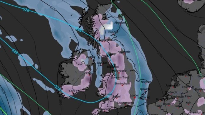

A significant weather system is on the horizon, with heavy snow expected to blanket the entire UK in the coming days.
Cutting-edge weather models indicate that a large portion of the British population may encounter substantial snowfall on December 30. The initial snowfall is predicted to start in the north-west of England, affecting areas like Manchester, Merseyside, and along the England-Wales border around 9 am. Devon and Cornwall could also witness snowy conditions during this time.
As the day progresses, the snow is anticipated to intensify along the England-Wales border, as well as over the Peak District, Yorkshire Dales, and Lake District. Southern parts of Scotland may also experience flurries.
By the afternoon, heavier and more widespread snowfall is expected. Maps for 3 pm show intense snow showers in Devon, parts of Wales, Oxfordshire, the Midlands, and the north-west of England. Scotland is likely to have less severe snowfall at this time, with cities like Edinburgh possibly being impacted.
Later in the evening at 9 pm, the maps indicate a significant snowfall over Scotland, particularly in Stirling, Perth, Kinross, the Highlands, and Lowlands. Light snow showers are also forecasted for the north-west of England and North Wales around this time.
Snow coverage maps for the morning of December 31 illustrate the extensive reach of the snow, with snow cover expected in most of Wales, parts of Northern Ireland, the majority of Scotland, and a large portion of England stretching from Plymouth to the far north.
According to data, the Scottish Highlands could see up to 10cm (four inches) of snow, while Wales may experience around 4cm, and the Pennines in northern England could see up to 2cm.
The Met Office has mentioned the possibility of “wintry showers” in various parts of the country leading up to the end of the year, with a cooling trend in temperatures.
The Met Office’s forecast for December 24 to January 2 suggests a transition to more settled conditions with high pressure building to the north of the UK. This will bring colder temperatures due to a strengthening easterly wind, with dry weather expected but occasional wintry showers, especially in eastern and southern regions. As the New Year approaches, high pressure is likely to dominate, maintaining settled conditions with a chance of showery weather later on. Temperatures are expected to be below average with frost likely under clear skies and light winds.