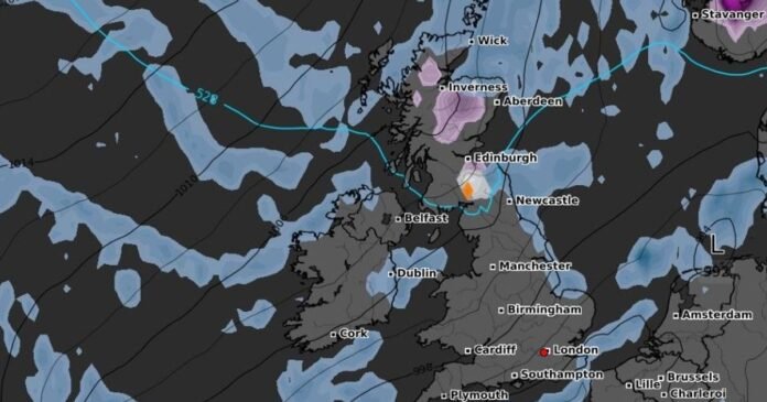
Britons are bracing for a blast of Arctic air in the upcoming weeks, with temperatures expected to drop to -2C, bringing the potential for hazardous freezing rain and snow.
Following a period of mild weather earlier this month, conditions have turned notably colder and more unsettled, as low-pressure systems move in from the Atlantic. While some snow flurries may be seen over elevated areas this week, the real chill is expected to set in during November.
WXCharts’ maps indicate that temperatures will dip into single digits in the first week of November, plummeting to below zero by November 12, particularly in Scotland, where lows of -2C are forecasted. A map for midnight on November 11 shows snow predicted for central and southern regions of Scotland, accompanied by a patch of freezing rain denoted in orange.
Freezing rain, a rare form of liquid precipitation that freezes upon impact with a cold surface, poses significant dangers, especially for driving, as it can create a sheet of clear ice. The Met Office warns that the weight of the ice could lead to tree and power line damage, while the icy glaze on surfaces turns roads into treacherous paths and poses risks to aircraft.
Looking ahead, the Met Office anticipates overnight fog and frost for the latter part of November. The forecast from November 11 to 25 suggests unsettled conditions initially, with showers, longer rainy spells, and potential strong winds across the UK. However, the latter half of the month may bring drier and finer weather, interspersed with bouts of fog and frost, primarily affecting the north of the UK.
The first 10 days of November are expected to bring more unsettled weather, possibly including heavy rain and strong winds, with the potential for severe gales. The prevailing low-pressure systems are likely to continue, leading to further showers and rainy periods, particularly in western regions.
Westerly or southwesterly winds are expected to bring above-average temperatures initially, reducing the likelihood of overnight frost and fog compared to normal conditions. Strong winds, including gales and severe gales, may occur intermittently, alongside periods of drier weather, more frequently in eastern areas.
Opting out of data sharing can be done at any time by clicking the “Do Not Sell or Share my Data” button at the bottom of the webpage. By continuing to use our website and services, you indicate your consent to our cookie usage and acknowledge our Privacy Notice and Terms and Conditions.
