
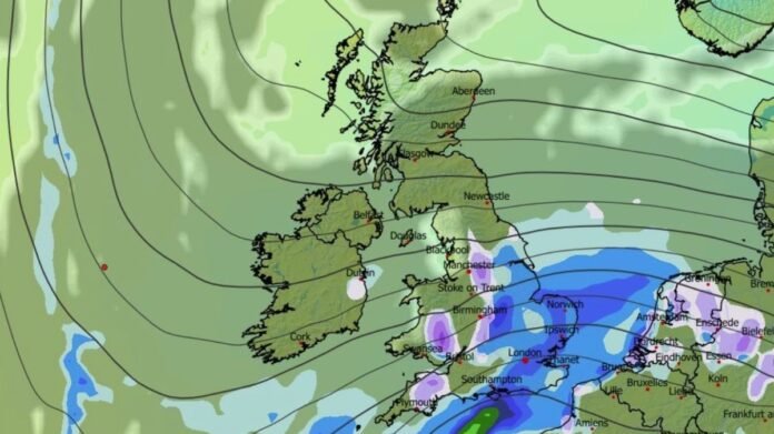

Britons may face a chilly Christmas this year, as unfavorable weather conditions are expected to persist in the upcoming days. According to the latest weather maps from WXCharts utilizing MetDesk data, snow is projected to move across Europe towards the UK on Christmas Day. The most recent forecasts suggest that some mountainous regions in Scotland, northern England, and Wales could see snow cover on December 25.
The maps indicate that snowfall will extend across the country from south to north during the day, reaching Scotland in the late afternoon. This weather system could evoke memories of the notable Beast From The East event in 2018, characterized by heavy snowfall and frigid temperatures as low as -14C due to an air mass from Siberia.
Although the Met Office has not yet confirmed the likelihood of snow on Christmas Day, their extended forecast anticipates continued unsettled conditions. From December 20 to December 29, the UK could experience periods of rain or showers accompanied by windy weather. The Met Office mentioned a potential increase in high-pressure systems near the UK in the lead-up to Christmas compared to previous weeks.
The forecast suggests a gradual drop in temperatures with a higher chance of overnight frost and fog, which may linger due to the season. As the end of December and start of January approach, Britons are expected to encounter dry and stable weather conditions with cooler temperatures. The Met Office’s long-range forecast from December 30 to January 13 highlights the likelihood of sustained dry and stable weather conditions, potentially with the onset of more changeable weather patterns later in January.
Recent weather alerts, including an amber rain warning for parts of Wales, have been issued across the UK. Heavy rainfall is predicted in south and southwest Wales, with significant amounts expected, potentially causing flooding and disruptions to communities.
The Environment Agency has issued flood warnings for multiple regions, including the Lake District, and alerts for possible flooding. The Met Office emphasized the risks associated with the ongoing wet weather and saturated grounds, which could lead to power outages, deep floodwater, and threats to life.
Warnings for heavy rain and potential travel disruptions remain in place for various regions until Monday evening. Despite a brief respite on Tuesday with clear skies and colder weather, wet and windy conditions are likely to return on Wednesday, extending through the rest of the week.