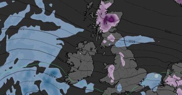
Recent icy-blue weather maps indicate that a significant portion of the UK is preparing for an intense 192-hour period of snow and Arctic conditions with temperatures dropping as low as -6C.
Over the upcoming weekend, the UK can anticipate relatively mild November weather, with London enjoying temperatures around 15C. Rain bands will slowly progress eastwards, giving way to clearer skies later on.
However, the latest WXCharts.com projections for mid to late November paint a different picture, foreseeing a sudden change as frigid Arctic conditions grip the nation. Beginning on Saturday, November 15, Scotland, the north-west of England, and the Midlands are likely to experience snowfall, with temperatures in the Scottish Highlands plummeting to -2C.
By Sunday, November 16, fresh snowfall is predicted in Wales and the north-west of England. Maps show that the previous day’s snow will have settled in Scotland, with temperatures reaching -3C in North-west Scotland and 0C in Wales.
Moving into Monday, November 17, weather charts suggest snow cover from Scotland to Cumbria and Snowdonia in Wales, with temperatures dropping to a bone-chilling -5 and -6C.
By Tuesday, November 18, Ireland, mid-Wales, and Scotland are expected to still endure temperatures as low as -5C, with heavy snow persisting in the Highlands. Wednesday, November 19, will maintain these sub-zero temperatures at -5C, as reported by the Express.
On Thursday, November 20, temperatures are likely to remain at -3C north of the border, while new snowfall is anticipated in Wales, with Scotland still blanketed in snow.
The cold spell, spanning from November 15 to November 22, will encompass a total of 192 hours of freezing conditions.
Long-range forecasts from the Met Office for the period between Tuesday, November 11, and Thursday, November 20, suggest a significant drop in temperatures towards the end of the month.
According to the forecast, the early part of this period is expected to be unsettled and relatively mild, with rain bands moving across various regions of the UK, particularly focusing on western and southern areas.
“Locally strong winds may accompany the rain at times. There will also be some drier intervals, more likely towards the east and potentially the north.
“Under clear skies and light winds overnight, frost and fog are expected, with the fog persisting for some time.
“Around the middle of the month, a shift towards drier weather nationwide is anticipated, accompanied by slightly cooler temperatures overall and an increased risk of overnight frost.”
<p class="CIPAConsentNotice_cipa-info__p
