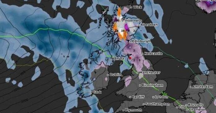
Parts of the UK are bracing for a significant snowfall of up to 20cm later this month as temperatures drop following a mild autumn. Weather forecasts indicate that some regions could experience wintry conditions with freezing rain or snow towards the end of November. Projections from WXCharts suggest that areas in northern England, Wales, the Irish border, and Scotland may see substantial snowfall on Saturday, November 22.
The Winter Overview map from WXCharts highlights the potential for snow accumulation in Manchester and areas further south, with Edinburgh expected to receive even more snow. The Scottish Highlands are forecasted to have significant snow depths even before the official start of winter, with areas west of Inverness potentially experiencing intense snowfall rates.
Parts of north Wales, Northern Ireland near the Republic of Ireland border, and the Scottish Highlands are expected to be covered in snow by midnight on November 22. Additional weather maps predict varying snow depths across different regions, with the Scottish Highlands possibly receiving up to 40cm of snow.
Even Edinburgh, in the south, could see snow accumulation, while parts of the West Country are preparing for a drop in temperatures and possible snowfall. However, the long-range forecast from the Met Office suggests lower levels of snow in low-lying areas during this period due to uncertainties in weather patterns. The forecast indicates a chance of dry weather with potential fog, frost, rain, and hill snow, along with near-average temperatures and possible colder spells.
Overall, the weather outlook for late November into early December remains uncertain, with a mix of weather conditions expected across the UK.
